Moorings, Anchorages and Marinas on the Brisbane River
 |
Australia, QLD, Brisbane: moorings, anchorages and marinas on the Brisbane river The Brisbane river is navigable for sailbaots about 12nm upstream right into the heart of Brisbane. Moorings, anchorages and marinas invite a stay. |
Brisbane is a popular stopover for cruisers during the cyclone season, and offers several marinas in Moreton Bay as well as moorings, anchorages and marinas in the Brisbane river. I will focus on the river in this article. The Brisbane river is navigable for sailboats all the way into the heart of the city. Brisbane is the capital of Queensland and the 3rd largest city in Australia with a total population of 2.4 million people in the metropolitan area. The locals, who call themselves Brisbanites, are very friendly and have a sunny disposition, probably a result of the high quality of life and the year round sunshine they enjoy. The city center is modern, very clean and shiny, has plenty of parks and green areas and is located right next to the Brisbane river, but let's start with the approach to the river and the city.

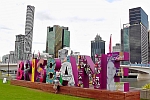
Brisbane is a friendly, modern, subtropical city and a popular stopover for cruisers. The city center is right along the Brisbane river, QLD, Australia.
When you arrive by boat you first have to navigate through Moreton Bay, a beautiful cruising ground with several islands, plenty of spots to anchor, swim, snorkel, dive, or just relax. However Moreton Bay is also very shallow in places and is known for its numerous sand banks, so it's a good idea to pay close attention to the charts, the color of the water, and your depth sounder. For the novices to the Bay, it's probably best to stick to the main shipping channel, although we found it safe to take at least one shortcut to avoid the strong outgoing current (up to 3-4 knots) in the main channel.

We took a shortcut and had no problems on this route with our 5'6" draft close to a low tide. The way points (Brisbane shortcut 1-3 are:
waypoint 1: 27° 06.0890' S, 153° 18.1570' E; waypoint 2: 27° 09.3400' S, 153° 15.6060' E; waypoint 3: 27° 11.4700' S, 153° 12.9160' E)
(Depth on chart is given in meters, not to be used for navigation.)
When you approach the mouth of the Brisbane river, the large cranes of the Port of Brisbane are visible from afar. The entrance channel into the river (waypoint 27° 18.6219' S; 153° 12.5501' E) is well marked and when going upstream you can make shortcuts on port but you should stay within the markers on the starboard side, otherwise you'll attract a crowd after getting stuck in the mud. The best time to approach the river mouth is at or just after slack tide following a low tide. This way the incoming tide will push you "upstream" and the 3+ knots will work in your favor, guaranteeing a smooth and fast ride. The ride upstream to the center of Brisbane is about 18nm from the river channel entrance buoy and 12nm from the mouth of the river. The 18nm will take about 3 1/2 hours at 5kts, 4 1/2 hours at 4kts, and forever if you are trying to go against the tide.
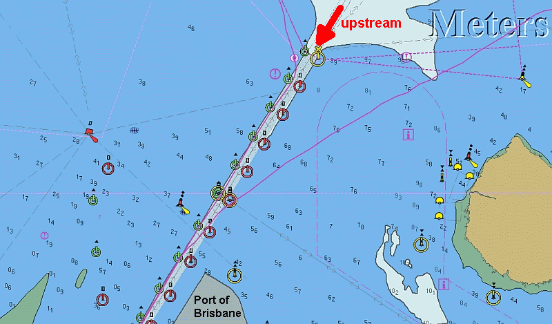
The entrance channel to the Brisbane river is well marked (the solid gray area on the chart). The solid purple lines are our tracks. While it's good
to stick to the channel markers on starboard, when going upstream, we found shortcuts on the port side were no problem since we never
encountered less than 10ft of depth. (Depth on chart is given in meters, not to be used for navigation.)
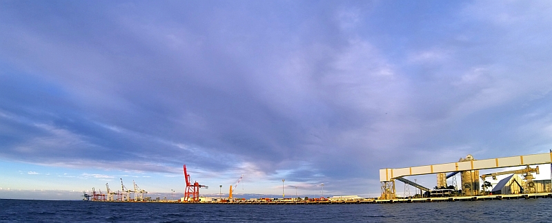
The Port of Brisbane is located on reclaimed land, once know as Fisherman Islands, and is the nation's fastest growing container port. The
large cranes are visible from afar. This picture was taken after we passed the port on our way upstream.
Once in the rivaa, yes that's how Australians pronounce "river", the first popular anchorage will appear on port, about 8.5nm after the first river channel entrance buoy, and is known as Aquarium passage (waypoint 27° 25.7909' S; 153° 07.7709' E). Actually it's the Bulimba Creek, but the passage got named after an aquarium which once stood there next to a zoo and entertainment park. But this was a long time ago and the Brisbane River showed its wild nature and washed it all away in the big floods of 1893. Now the passage seems rather shallow. We tried to enter it when we first explored the river, but we backed up after our depth sounder read 8ft at the entrance during high tide, and after we realized that most of the boats anchored or moored there were cats or trimarans. The charts show that you should have 1-2m at high tide - not much! If you are adventurous, let us know how it went in case you decide to venture in there. Doing so is also a great opportunity to connect with the friendly volunteers of the Coast Guard Brisbane Marine Assist, which tow vessels and are stationed in Manly.
Coast Guard Brisbane Marine Assist
Email: This email address is being protected from spambots. You need JavaScript enabled to view it.
Mail: PO BOX 5014, Manly, QLD, 4179
Adress: 40 Traflagar St Manly QLD 4179
Radio Frequencies Monitored: VHF: 16 63 67 73 21 81
Phone: (07) 3396 5911
Mobile: 0404 466 000

The Aquarium Passage seems to be best suited for shallow draft vessels. (Depth on chart is given in meters, not to be used for navigation.)
Continuing up the river you will reach River Gate Marina (waypoint 27°26.67’S, 153°06.30’E) on your port side. The Marina is the official Customs and Quarantine Clearance point for South East Queensland. So if you haven't cleared in yet, the customs dock in Rivergate needs to be your first stop (Department of Immigration and Border Protection; phone: 07 3895 6910; email brisseaATborder.gov.au). While the marina is geared towards superyachts they are very friendly and also accommodate cruisers. However, the last time we checked, there was no public transport to the city center and the surrounding area can be best described as an industrial/commercial district.
View of Rivergate Marina with custom dock. Yes, the first thing you see when you arrive in Australia by boat is a metal fence. The Gateway
Bridge can be seen in the background.
Rivergate Marina
The marina can accommodate vessels from 8 to 80m and is located 3 nautical miles from the Brisbane city centre. The facilities include a fuel dock which is open 7 days a week serving diesel, unleaded and premium unleaded, a sewer pump out station, amenities block, electricity and fresh water. Wireless broadband, a laundry and a cafe are also available. Rivergate’s shipyard includes a 12,000sqm hardstand, 75 and 300 ton travel lifts and over 300 approved contractors in over 20 trades.
Latitude: 27°26.67’S
Longitude: 153°06.30’E
Phone +61 (0) 7 3907 1600
Email: infoATrivergate.com.au
Address: Rivergate Place, Murarrie Brisbane Queensland 4172, Australia
URL: http://rivergate.com.au/marina/
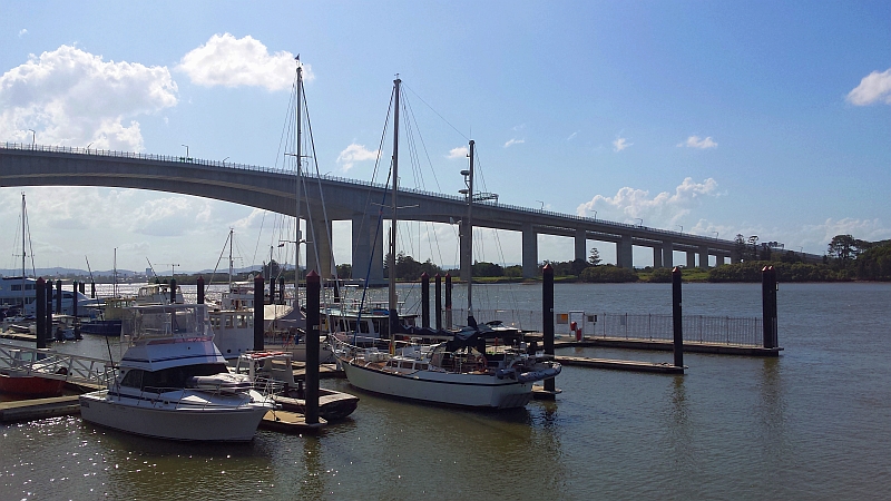
Right next to River Gate marina is the Gateway Bridge, with enough clearance to let cruise ships pass underneath and they do venture that far up the river, so don't be surprised if one of those giants appears right next to you. By the way, the Gateway Bridge was renamed in 2010 to Sir Leo Hielscher Bridge by some politicians to honor their buddy Leo, but the public was against this decision and everybody still calls it Gateway Bridge. Anyway, we found a suitable anchorage right after the Gateway Bridge to starboard just outside the shipping lane (waypoint 27° 26.7959' S; 153° 05.3608' E).
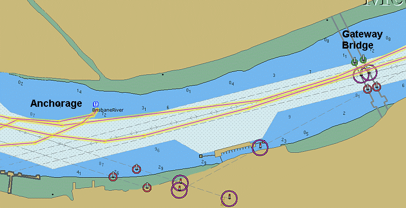
The anchorage area upstream of the Gateway Bridge. Besides the airplanes passing overhead (the main flight corridor to the Brisbane airport
crosses the river here), it was a good spot to spent the night.
Motoring around several more bends in the river (sailing is pretty much impossible since the wind changes after each bend) brings you to the Dockside Marina, the second of the only two marinas on the Brisbane river. The Dockside Marina berths are the closest ones to the city center, and the marina features a laundry facility, showers and toilets and is located next to cafes, restaurants, a bottle shop, a small grocery, a hair salon and the Dockside Hotel on Kangaroo Point. The free "City Hopper" ferry leaves from the marina and crosses the river to bring you to the city center. Finding the marina manager's office can be challenging, since it got relocated on level 2 of the car park, after the original office on the river got struck by lightning and was turned into dust. To aid, here are the coordinates of the new office: 27°28'18.1"S 153°02'13.1"E, which is open Monday to Friday 7.30am to 3.00pm. The Wi-Fi got washed away in the floods of 2011, the berths closest to shore can be explored on foot at low tide, and the docks are in a rather sad shape, but it is the only marina with easy city access and thus a popular spot.
Passing Dockside Marina to port, located in front of three prominent appartment towers, we approach the Story Bridge.
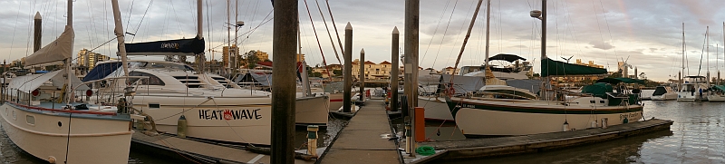
Green Panther and friends moored at Dockside Marina. We are still here as I am writing this, since we have great neigbors, easy city access,
and can ride the bicycle trail to work. Plus the constant wake from the city ferries guarantees that we don't loose our sealegs ;-).
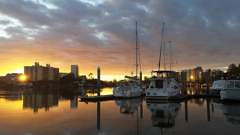
Dockside Marina can be a peaceful place before the communter traffic via city ferries starts at 6am. The early bird catches the relaxing view
.
Dockside Marina
Latitude: 27° 28.370’S
Longitude: 153° 02.238’S
Mobile: +61 413 616 268
Phone: +61 7 3891 6677
email: docksidemarinaATgirdis.com.au
Address: Dockside Marina, 44 Ferry Street, Kangaroo Point Qld 4169
URL: http://www.docksidemarina.com.au
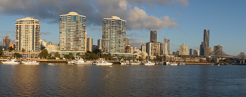
Passing Dockside Marina, you will see a local icon, the Story Bridge, emerging in front of you. The steel bridge was opened in 1940 and initially a toll of sixpence (5 cents) was charged, but the toll was removed in 1947 and now crossing the bridge is free, like so many things in Brisbane. The adventurous can book a climb to the highest point of the bridge (just google "Story Bridge Adventure Climb"). Anyway passing under the bridge is easy since the clearance is 30.4 metres (99.7 ft) at mid-span. On the other side of the bridge the towering skyscrapers of Brisbane City, commonly referred to as the CBD (Central Business District), emerge to starboard.
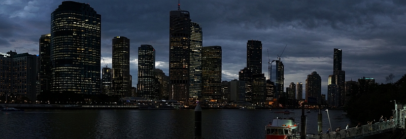
Brisbane's city center, known by locals as Brisbane CBD (Central Business Disctrict) just after sunset. Note the red free "City Hopper" ferry
disembarking passengers in the foreground onto Kangaroo Point.
Past the high rise buildings and the ferry terminals starts another green section of the river, with the Kangaroo Point cliffs to port and the City Botanic Gardens on starboard. In front of the gardens are the popular Gardens Point Moorings (waypoint 27° 28.4374' S, 153° 01.9079' E), the most central point you can park your boat in Brisbane. The moorings are very economical, and you get a fore and aft piling to tie up your boat. A dinghy dock and facilities including showers and laundry are on shore. The drawback is the river ferries constantly rock and roll the boats, sometimes violently, and that it's not possible to make a reservation in advance. The moorings are rented on a first come first serve basis and the contact is the Brisbane City Council. Here is what they said about the moorings in 2016:
Council does not take bookings for moorings, as they are available on a “first in - best dressed” basis. Occasionally, vessels leave the moorings for slipping and other maintenance works, or to go short-term cruising. Therefore if the mooring is intended to be reserved, normally the vessel owner ties a rope between piles. If there is no rope, then the mooring is vacant, and you can secure your vessel there.
Payment is made at the King George Square Car Park, 100 Adelaide Street Brisbane, Level B1 office, where you will be asked to sign a Casual Mooring Permit application form. You must also produce the following:
- A copy of a current Boat/Car Licence (Master or person responsible for the vessel)
- A copy of a current 2016 Certificate of Currency for Liability Insurance (minimum coverage $10 million), and
- Details of ownership and registration of the vessel, and details of LOA and displacement.
The current fees are $70 per week, inclusive of GST. Payments in advance are possible for a maximum of two weeks ($140).
The facilities are intended to be for the use of transient visitors to Brisbane, from the international, interstate and intra-state boating fraternity. It is desirous that the vessels moored are occupied, so that the condition and security of the mooring lines can be monitored by the owner. Council does not encourage the storage of unoccupied vessels in this location, and all vessels are required to be navigable and sea-worthy.
Just upstream of the moorings is another popular area which allows a limited number of boats to anchor (waypoint 27° 28.6041' S, 153° 01.9523' E) as long as they stay outside the main shipping channel. Here the same is true as for the rest of the river, triple check that your anchor holds well in the mud, because the currents runs at 3+ knots and changes direction four times a day.
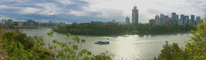
View from the cliffs at Kangaroo Point across the river to the City Botanic Gardens with boats anchored in front of it. The Gardens Point Moorings can
be seen on the right as well as the Brisbane CBD. The Captain Cook Bridge is located upstream (to the left).
That's pretty much it, since the next bridge upstream after the City Gardens is the Captain Cook Bridge, named in honor of the famous captain and pioneer who discovered the world by sailboat. However, since Australians love ironic jokes, they built the bridge in honor of the famous sailor way too low for most sailboats to to pass (it has a meager vertical clearance of 12.7 meters (42 ft)). Anyway if you decide to set the hook or moor in beautiful Brisbane, then make sure to enjoy the free WiFi in all public parks, take the free ferry "City Hopper" up and down the river, and relax in the free pool and city beach in the South Bank Parklands (waypoint 27° 28.5707' S, 153° 01.3079' E). Enjoy Brisbane mate.
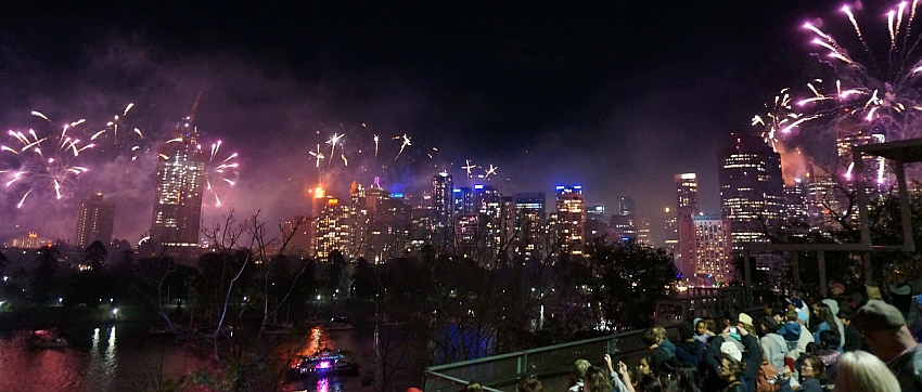
If you happen to be in Brisi in September then mark your calendars for the annual "RiverFire" fireworks event, it's quite a show.
Cheers,
Chris and Alena
p.s.: To use the email addresses on this page, replace AT with @